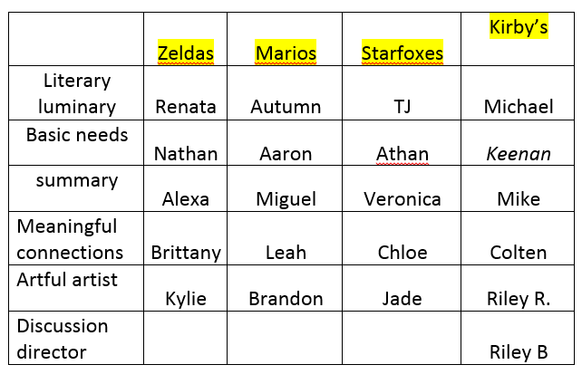
April
14
April
12
Math – Adding Fractions with Like
April
11
Maps to use for Zombie Outbreak
April
10
Bridge Construction – Research and Review
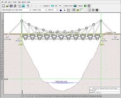 Okay, so Mr. Ewert said “For this project you will need to research bridges and their construction…” but I don’t even know where to start! I’m freaking out here! But wait, he always says boring things like “Have you checked the blog?” and “What do you think to you could do to find out?” Maybe I should try asking myself those questions.
Oh look, Mr. Ewert DID put something on the blog to help me. These links might be helpful.
http://science.howstuffworks.com/engineering/civil/bridge2.htm
http://science.howstuffworks.com/engineering/civil/bridge4.htm
http://thenextgalaxy.com/advantages-and-disadvantages-of-truss-bridges/
http://healthresearchfunding.org/truss-bridges-pros-cons/ (watch the second video)
http://www.garrettsbridges.com/design/warren-truss/
https://www.youtube.com/watch?v=oVOnRPefcno (watch video)
https://www.youtube.com/watch?v=KBOGRxV49MQ (watch video)
http://www.pbs.org/wgbh/buildingbig/bridge/basics.html
http://www.brighthubengineering.com/structural-engineering/63635-truss-bridge-designs/
And he also highly suggests using this website to help me think about how I want to design my bridge.
April
7
Grade 4-5 Social Studies – Vikings and Early European Explorers
April
6
Quickwrite – 9 year old reporter

April
5
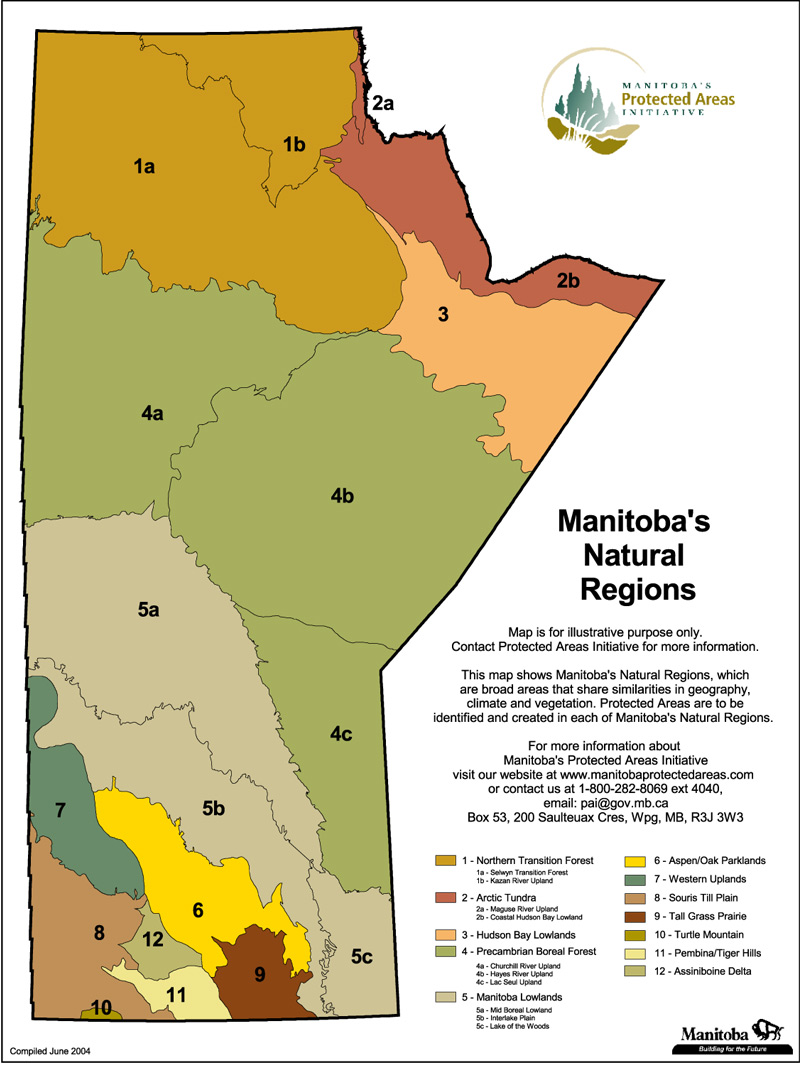
Social Studies – Links to Maps
Students are collecting links to maps for us to use in predicting the patterns of the zombies. Use the link below and pasted helpful links.
https://docs.google.com/document/d/1eONU_9A2sP1tGn8Oo2LzGdpX8Ff-q8HOOx9EklSepIM/edit?usp=sharing
April
5
zombie outbreak
My assignment is right here -> https://mrewert.edublogs.org/2016/04/04/the-zombie-outbreak-is-here/
If there was a zombie outbreak and I needed to prepare I would…
What will I do when the outbreak happens?
I will probably start to prepare. I would run away from them before they could get me and go tell people about it. I would try
Food:
I would want to get food that doesn’t expire because you never know how long the zombies will be there.
For example
Rice
Honey
Jello
And maple syrup
Drinks:
I would mostly get water. I would need a lot of water because it only takes like 4 day to die without water.
I could get juice because it takes a long time for juice to go bad.
Who would I go with?
I would go with kylie Brittany and chloe. Because they are smart people and they can help me with ideas.
Supplies
Supplies that I would get would be
A backpack for I don’t have to hold anything. I would want rope to help me make a fire. I might even need the rope to climb a tree. I might need to climb a tree if there is a zombie trying to get me.
A map and a pencil for I can keep track of where I am and a safety kit.
Safety
In the safety kit I would have polysporn band aids. I would aslo have Advil and Tylenol just in case I get sick and a teensier bandage in case I sprain something.
Weapons
For weapons I would have a knife an ax and gun just in case.
Where I would go?
I would want to go near water. Maybe beside a lake or a river for I can drink water. There is usally trees by water so that is good. I might need to make a fire to stay warm so I can use sticks.
April
5
The Giver – Questions for Ch. 17 – 19
April
5
Social Studies – Getting to know maps
Today we are starting our orientation with maps. We will be taking a pre-assessment quiz on maps and common terms and then observing some different types of maps.
Use the links below to help you experience different types of maps and their uses.
Map of Manitoba
https://www.google.ca/maps/@50.7730957,-97.4885427,9z
Satellite map of Manitoba
https://www.google.ca/maps/@50.7730957,-97.4885427,124187m/data=!3m1!1e3
infographic map of Canada – infographics on water
infographic map of Canada – infographic on hunger
GIS of Manitoba – resources
Road maps
http://www.gov.mb.ca/mit/map/index.html
Topographical map of Manitoba
http://en-ca.topographic-map.com/places/Manitoba-688265/